
Spatial analysis
The algorithm toolbox of IRI.Maptor.Core.Spatial: triangulation and Voronoi diagrams, convex hulls, line simplification, topology predicates, space-filling curves, and network building — all on plain geometry types, no UI dependencies.
Delaunay triangulation & Voronoi diagrams
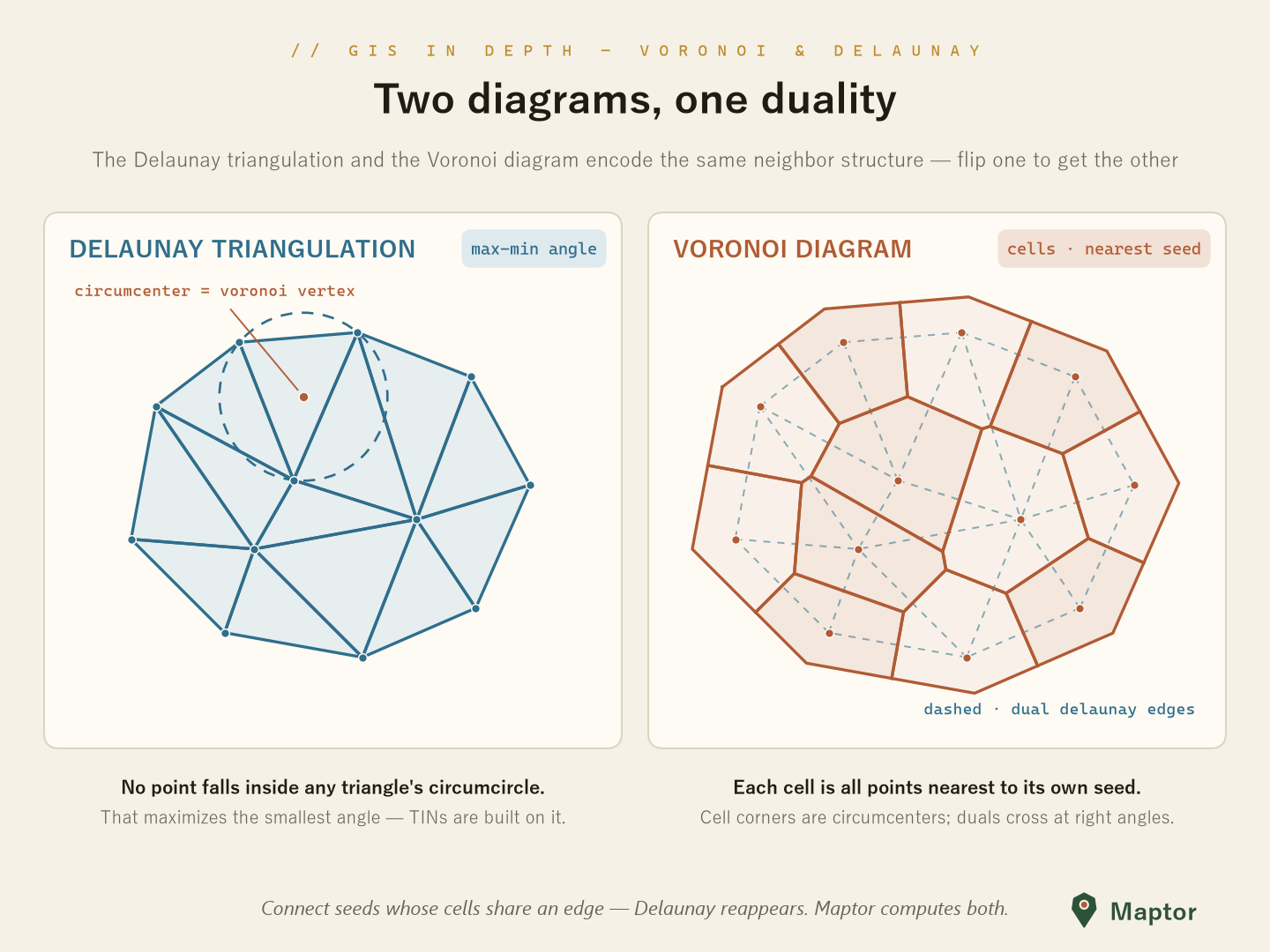
DelaunayTriangulation is a Bowyer–Watson incremental insertion. Triangles come back as CCW vertex indices with per-edge neighbour links (-1 on the convex hull), and the dual Voronoi diagram comes for free: every triangle's circumcenter is a Voronoi vertex, and hull cells stay open as infinite rays.
using IRI.Maptor.Core.Common.Primitives;
using IRI.Maptor.Core.Spatial.Analysis;

var triangulation = DelaunayTriangulation.Create(points);      // IReadOnlyList<Point>, ≥ 3 points

var triangles = triangulation.Triangles;                       // CCW indices + neighbours
int hit       = triangulation.FindContainingTriangle(p);       // walk; -1 outside the hull

var voronoi = triangulation.GetVoronoiDiagram();               // or VoronoiDiagram.Create(points)
// voronoi.Cells (IsClosed = false on the hull), voronoi.Edges (rays have VertexB == -1)
Convex hull
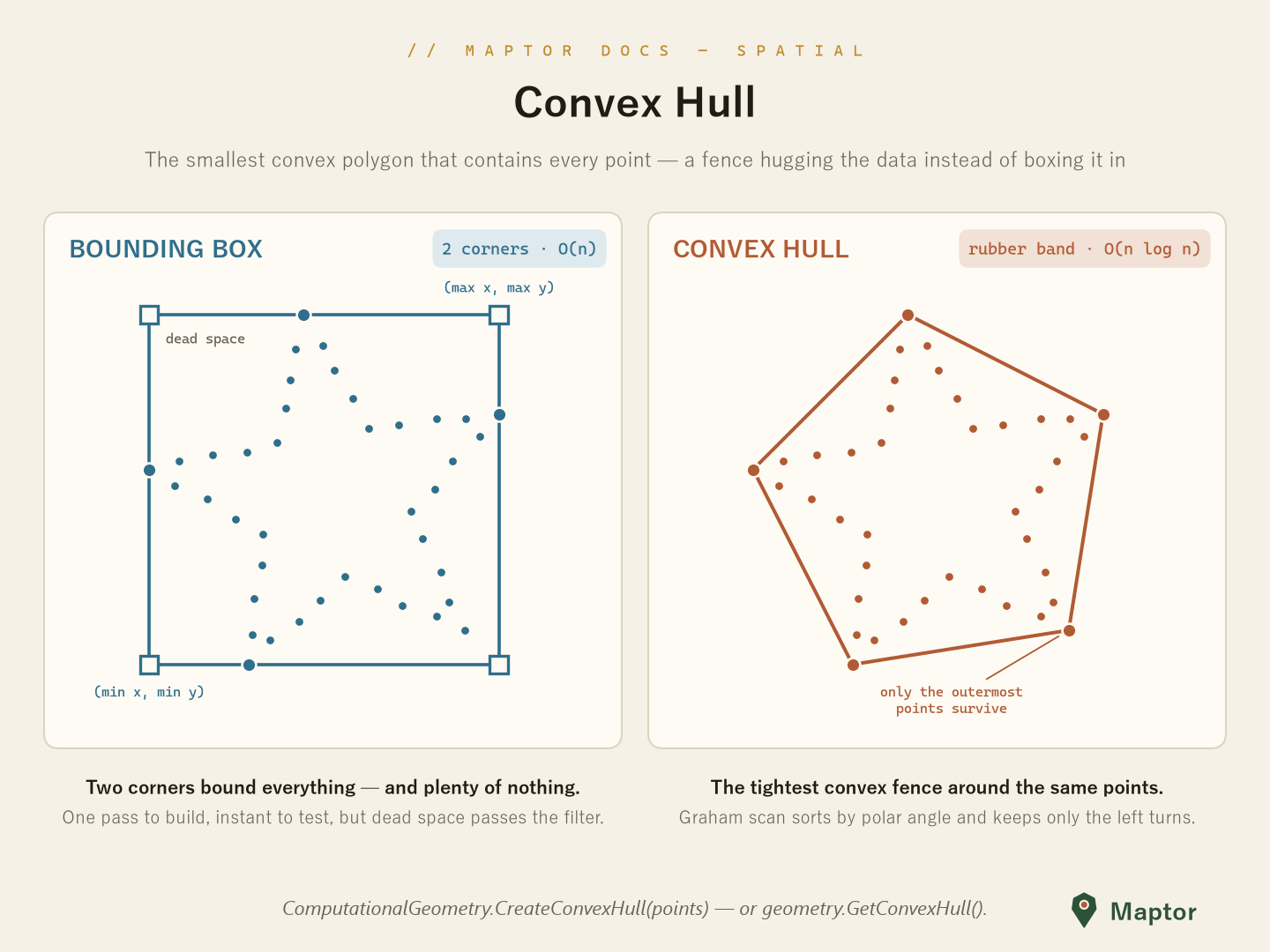
The convex hull is the smallest convex polygon that contains every point of a set — stretch a rubber band around the points and let it snap tight: it hooks onto the outermost points and skips everything inside. Where a bounding box spends two corners enclosing plenty of dead space, the hull is the tightest convex fence the data admits — the natural answer to "what area does this dataset actually cover?".
ComputationalGeometry.CreateConvexHull is a Graham scan — sort by polar angle around the lowest point, keep only the left turns, O(n log n). It returns the hull vertices counter-clockwise; duplicates and collinear edge points are dropped.
// a five-pointed star: five outer tips plus five inner notch points
var points = new List<Point>
{
    new Point(0, 10),     new Point(-9.5, 3.1),  new Point(-5.9, -8.1),  // outer tips …
    new Point(5.9, -8.1), new Point(9.5, 3.1),
    new Point(-2.4, 3.2), new Point(-3.8, -1.2), new Point(0, -4),       // … inner notches
    new Point(3.8, -1.2), new Point(2.4, 3.2),
};

List<Point> hull = ComputationalGeometry.CreateConvexHull(points);
// → the five tips, counter-clockwise — a pentagon; the rubber band bridges
//   every notch straight across, and the inner star vertices vanish

var hullPolygon = geometry.GetConvexHull();   // same thing on any Geometry<T>
Simplification
Simplifications collects ~20 line-simplification algorithms behind one shape: SimplifyByXxx<T>(List<T> points, SimplificationParameters parameters) where T : IPoint. Thresholds ride in SimplificationParameters (DistanceThreshold, AreaThreshold, AngleThreshold — the square cosine of the angle — N, LookAhead, Retain3Points).
| Family | Methods |
|---|---|
| Global tolerance | SimplifyByRamerDouglasPeucker |
| Area-based | SimplifyByVisvalingamWhyatt (extra bool isRing), SimplifyByAdditiveAreaPlus, triangle-routine family |
| Corridor / sleeve | SimplifyByReumannWitkam, SimplifyByPerpendicularDistance, SimplifyBySleeveFitting, opening-window pair |
| Local geometry | SimplifyByAngle, SimplifyByEuclideanDistance and their cumulative variants, SimplifyByLang |
| Sampling | SimplifyByNthPoint, SimplifyByRandomPointSelection |
| Segment collapse | SimplifyByAPSC (Kronenfeld et al. 2020 — minimizes areal displacement) |
var parameters = new SimplificationParameters { DistanceThreshold = 0.001 };

var simplified = Simplifications.SimplifyByRamerDouglasPeucker(line.Points, parameters);
SimplificationMetrics scores the result with McMaster's measures: PercentageChangeInLineLength, PercentageChangeInCoordinates, PercentageChangeInPointDensity.
Topology
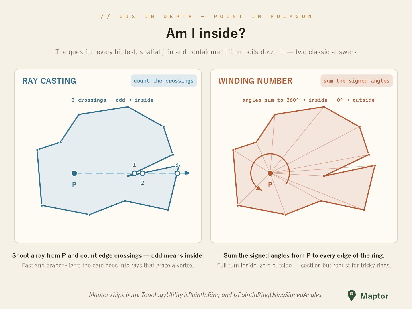
The Topology/ enums (PointPolygonRelation, LineLineRelation, PointCircleRelation, …) name the answers; the predicates live in TopologyUtility (namespace IRI.Maptor.Core.Spatial.Helpers). Point-in-polygon ships in both classic flavours:
using IRI.Maptor.Core.Spatial.Helpers;

bool inside  = TopologyUtility.IsPointInRing(ring, point);                  // even-odd ray casting
bool winding = TopologyUtility.IsPointInRingUsingSignedAngles(ring, point); // winding number
bool inPoly  = TopologyUtility.IsPointInPolygon(polygonOrMultiPolygon, point);
Also here: segment–segment intersection (LineSegmentsIntersects), point–segment distance, the point/circumcircle test (GetPointCircleRelation), and left/right-of-vector classification (GetPointVectorRelation, with an optional tolerance).
Point-in-polygon across spatial reference systems
Everything above assumes both operands live in the same SRS. When they don't — a point layer in one system, a polygon layer in another — the direction you reproject decides whether the answers are true:
Run the containment test in the polygon layer's SRS: reproject the point layer into the polygon's SRS, never the polygon into the point's. A point reprojects exactly; a polygon does not.
The tempting optimization
Given points in SRS A and polygons in SRS B, the cheap way to reconcile them is to transform the polygons into A and test there: a handful of features with a few hundred vertices, against a point layer that may hold millions of rows. The cost argument is real. The result is wrong.
Why moving the polygon breaks the answer
A polygon is stored as vertices plus implied straight edges. Reprojection transforms only the vertices; each edge is then redrawn as a straight chord between the transformed endpoints in the target SRS.
But a straight line in one SRS is not a straight line in another. Any non-linear transform — geographic to projected, or between two projections — maps a straight segment to a curve. The redrawn chord therefore deviates from the true image of the boundary:
- the deviation is zero at the vertices and largest at the middle of each edge;
- it grows with edge length — long, sparse edges are the worst case — and with the curvature of the transform in that area.
Every point sitting in the sliver between the chord and the true curve is assigned to the wrong polygon, which is precisely the near-border population a count is most sensitive to.
A point, by contrast, is dimensionless: it has no edges to redraw. Reprojection maps one coordinate pair to one coordinate pair, exactly (up to negligible numeric error). Move the points and nothing is distorted — the test then runs against the polygon where its edges are authoritative, the SRS its geometry was authored in.
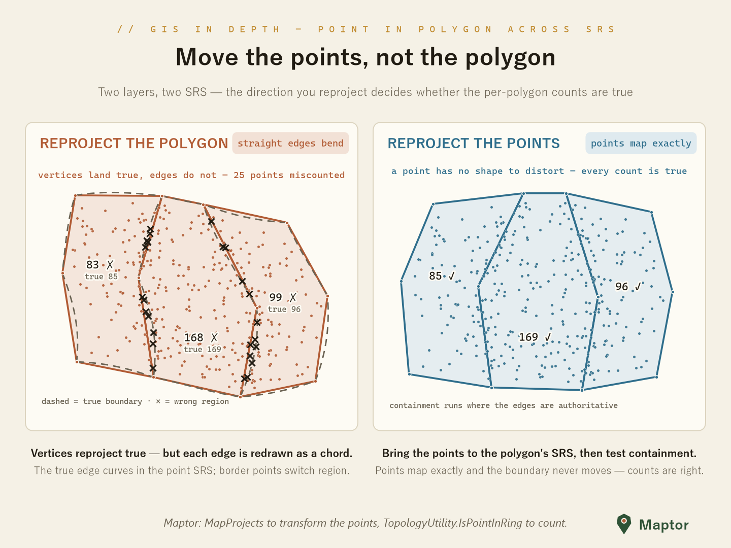
What the figure shows
Three regions with long shared borders and 350 points, under a simulated non-linear transform:
- Left — reproject the polygon. Vertices land true, but the solid chord edges drift off the dashed true boundary, and 25 points (the × marks) fall in the wrong region.
- Right — reproject the points. The same data in the polygon's SRS: edges straight and authoritative, every point mapped exactly, every count true.
Note the treacherous detail in the left card's labels. Although 25 individual points are misassigned, the per-region totals barely move — 83 vs 85, 168 vs 169, 99 vs 96 — because flips across each border go in both directions and largely cancel. Aggregate counts can look entirely plausible while the individual answers are wrong, so a "the totals look about right" spot-check will not catch this bug.
Doing it right
Transform the point layer with the projections in IRI.Maptor.Core.SpatialReferenceSystem, then count with the point-in-ring predicates above — in the polygon's SRS:
using IRI.Maptor.Core.Spatial.Helpers;
using IRI.Maptor.Core.SpatialReferenceSystem.MapProjections;

// polygons authored in UTM zone 39N; points arriving as WGS84 lon/lat
var utm = UTM.CreateForZone(39);
var ringBoundingBox = ring.GetBoundingBox();      // reused across every test

int count = geodeticPoints
    .Select(p => utm.FromGeodetic(p))                                     // move the POINTS …
    .Count(p => TopologyUtility.IsPointInRing(ring, p, ringBoundingBox));  // … then test there
It is a rule about dimension
Nothing here is specific to polygons, or to which layer you consider primary. Any predicate that mixes points with shaped geometry follows the same logic: reproject the dimensionless operand into the SRS of the one whose shape carries meaning.
Asking which transmission towers sit on a power line is the same problem one dimension down. The line is vertices plus implied straight spans; reprojecting it redraws every span as a chord that bows away from the true path, and towers genuinely on the line fall off it — worst at mid-span, exactly where the long crossings are. Move the towers into the power line's SRS and test there.
Nuances and edge cases
- If you truly must move the polygon — you need it in the other SRS anyway — densify its edges first: insert intermediate vertices along each segment, then reproject. Shorter segments mean smaller chords, which bounds the error; it is still an approximation. Moving the points is exact.
- The one exception. If the two SRS are related by a purely affine transform, straight lines stay straight and either direction works. In practice any projection change is non-linear, so treat the rule as universal.
- Authoritativeness. The result is correct with respect to the SRS the polygon was authored in. If a boundary is legally defined by geodesics on the ellipsoid rather than by its stored projected geometry, the authoritative form is the geodesic one — the rule generalizes to "test containment where the boundary definition is authoritative".
- Performance. Transforming millions of points does cost more than transforming a few polygons; that is the whole temptation. The cost is linear and parallelizes cleanly, and correctness is worth it.
Space-filling curves (SFC)
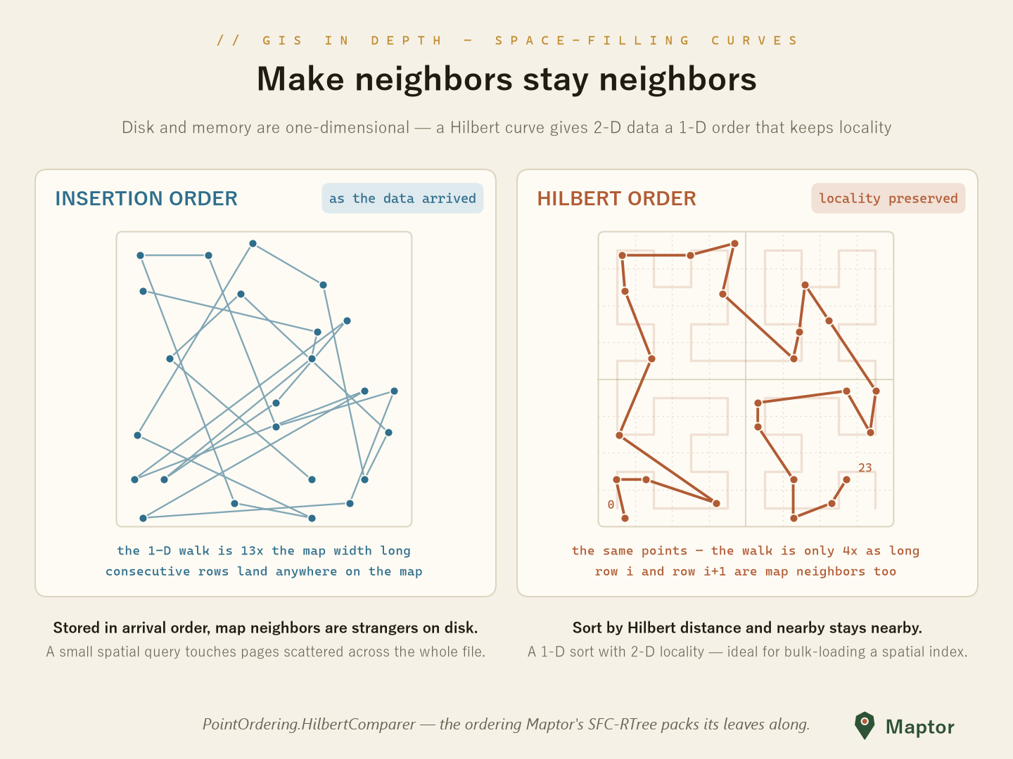
Hilbert, Z-order (Morton) and other curve orderings that linearize 2-D data while keeping neighbours close — the backbone of SFCRTree bulk-loading and locality-preserving sorts. See the dedicated SFC README.
Network
LineNetworkBuilder<T> turns a pile of line features into edge–node topology: coincident endpoints snap together within a tolerance, shared vertices become junctions, and the result bridges straight into the Sta.Graph algorithms.
using IRI.Maptor.Core.Spatial.Analysis.Network;

var network = new LineNetworkBuilder<Point>(LineNetworkBuilder<Point>.GetDefaultTolerance(srid))
                    .Build(lineFeatures);

var components = network.GetConnectedComponents();  // disconnected islands
var graph      = network.ToAdjacencyList();         // → Sta.Graph: Dijkstra, BFS, …
Statistics & shape characteristics
AreaStatistics summarizes the area distribution of a set of Geometry<Point> polygons (mean, standard deviation, histogram, CSV export). The CharacteristicsMeasure enum names McMaster's displacement measures (PCC, PDD, PCLL, …) computed by the simplification metrics above.
Going further
- Digital Terrain Modeling — grid DEMs, TINs, slope/aspect, volume
- Interpolation — inverse distance weighting (IDW)
NuGet: IRI.Maptor.Core.Spatial
Issues: GitHub Issues