
Ellipsoids and datums
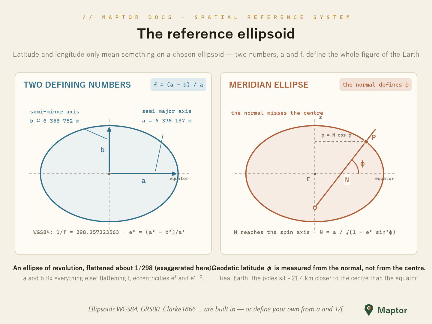
A latitude/longitude pair means nothing on its own — it is always measured on a chosen reference ellipsoid: an ellipse of revolution that approximates the figure of the Earth. Two numbers pin the shape down: the semi-major axis a and the flattening f = (a − b) / a (usually given as 1/f). Everything else — semi-minor axis b, first/second eccentricity e², e′², and the radii of curvature N (prime vertical) and M (meridian) — follows from them.
Ellipsoid<TLinear, TAngular>
Ellipsoid.cs is a generic struct (typed by linear unit, e.g. Meter, and angular unit, e.g. Degree) implementing IEllipsoid. It exposes:
- Geometry —
SemiMajorAxis,SemiMinorAxis,Flattening,InverseFlattening,FirstEccentricity,SecondEccentricity - Curvature —
CalculateN(latitude)(prime vertical) andCalculateM(latitude)(meridian) — see below - Datum definition —
DatumTranslation(aCartesian3DPointshift of the ellipsoid center) andDatumMisalignment(anOrientationParameter: rotations ω, φ, κ), which position a regional datum relative to the geocentric frame - Identity —
Name,EsriName,Srid(EPSG code)
Radii of curvature — M and N
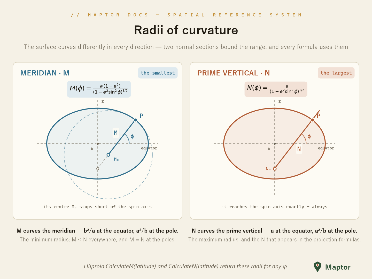
Unlike a sphere, an ellipsoid curves by a different amount in every direction at a given point. Two normal sections bound the range, and together they carry almost all of the geodetic math:
| Section | Formula | At the equator | At the pole | |
|---|---|---|---|---|
| M | along the meridian — the minimum radius | M(φ) = a(1 − e²) / (1 − e² sin²φ)^{3/2} | b²/a | a²/b |
| N | along the prime vertical (east–west) — the maximum radius | N(φ) = a / (1 − e² sin²φ)^{1/2} | a | a²/b |
M ≤ N everywhere, and the two become equal at the poles. Geometrically, N is the length of the surface normal from the point down to the spin axis — it reaches the axis exactly — while M's centre of curvature stops short of it. N is also the quantity that appears in the geodetic→Cartesian conversion and in the Transverse Mercator / UTM series.
var wgs84 = Ellipsoids.WGS84;

LinearUnit n = wgs84.CalculateN(new Degree(35.689));  // prime vertical radius
LinearUnit m = wgs84.CalculateM(new Degree(35.689));  // meridian radius
double meters = n.Value;                              // ≈ 6 385 415 m

// CalculateN also has a plain-double overload (latitude in degrees)
double nAtLat = wgs84.CalculateN(35.689);
Predefined ellipsoids: Ellipsoids
Ellipsoids.cs provides ready-made instances (Ellipsoid<Meter, Degree>). Notable ones:
| Property | a (m) | 1/f | EPSG |
|---|---|---|---|
Ellipsoids.WGS84 |
6 378 137.0 | 298.257223563 | 4326 |
Ellipsoids.GRS80 |
6 378 137.0 | 298.257222101 | 4019 |
Ellipsoids.WGS72 |
6 378 135.0 | 298.26 | 4322 |
Ellipsoids.International1924 (Hayford) |
6 378 388.0 | 297 | 7022 |
Ellipsoids.Clarke1866 |
6 378 206.4 | 294.9786982 | 7008 |
Ellipsoids.Clarke1880Rgs |
6 378 249.145 | 293.465 | 7012 |
Ellipsoids.Bessel1841 |
6 377 397.155 | 299.1528128 | 7004 |
Ellipsoids.Airy1830 |
6 377 563.396 | 299.3249646 | 7001 |
Ellipsoids.Sphere |
6 378 137.0 | ∞ (no flattening) | — |
…plus regional datums carrying a translation toward WGS84, e.g. Ellipsoids.FD58 (Final Datum 1958, used in Iran's oil industry) and Ellipsoids.NahrawanIraq.
Ellipsoids.WGS84 is a cached singleton; treat it as the default datum throughout the library.
Custom ellipsoid
using IRI.Maptor.Core.Common.Metrics;
using IRI.Maptor.Core.SpatialReferenceSystem;
using IRI.Maptor.Core.SpatialReferenceSystem.Models;

// simple: name, semi-major axis, 1/f, srid
var hayford = new Ellipsoid<Meter, Degree>("International 1924", new Meter(6378388.0), 297, 7022);

// full datum definition: with translation + orientation relative to the geocentric frame
var fd58 = new Ellipsoid<Meter, Degree>("D_FD_1958", new Meter(6378249.145), 293.465,
    new Cartesian3DPoint<Meter>(new Meter(-241.54), new Meter(-163.64), new Meter(396.06)),
    new OrientationParameter(new Degree(), new Degree(), new Degree()),
    4132);
To transform geodetic coordinates between two datums (G1 ↔ G2), use Transformations.ChangeDatum(...) from Transformations.cs.
Back to IRI.Maptor.Core.SpatialReferenceSystem · projections that consume these datums are documented in MapProjections.