
این صفحه هنوز ترجمه نشده است؛ نسخهٔ انگلیسی نمایش داده میشود.
Map projections
Map projections convert geodetic coordinates (latitude φ, longitude λ on a reference ellipsoid) into planar x/y coordinates and back. Every projection in this folder derives from MapProjectionBase (which extends SrsBase) and shares the same API:
TPoint FromGeodetic<TPoint>(TPoint point);   // (lon, lat) -> (x, y)
TPoint ToGeodetic<TPoint>(TPoint point);     // (x, y) -> (lon, lat)
int    Srid          // EPSG identifier
var    Ellipsoid     // the underlying horizontal datum
The heavy math lives in the static MapProjects class — the projection classes are thin, parameterized wrappers around it.
What is a map projection?
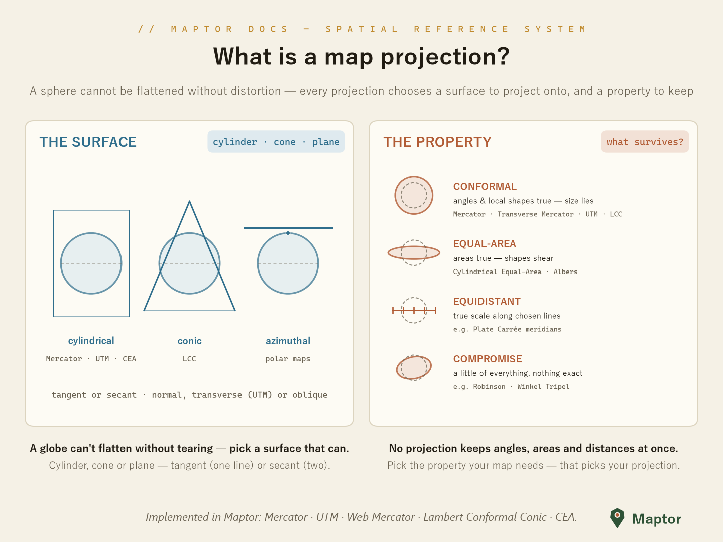
A sphere (or ellipsoid) cannot be flattened onto paper without distortion. Every projection therefore makes two choices:
The surface it projects onto — one that can be unrolled flat:
- Cylindrical — a cylinder wrapped around the globe (Mercator, Cylindrical Equal-Area; transverse aspect wraps it around a meridian instead: Transverse Mercator, UTM)
- Conic — a cone set over the globe (Lambert Conformal Conic)
- Azimuthal / planar — a plane touching the globe (polar and hemisphere maps)
The surface can touch the globe on one line (tangent) or cut through it on two (secant — UTM and 2-parallel LCC are secant, which spreads the low-distortion band wider).
The property it preserves — because it can't preserve everything at once:
Class What survives What lies In this library Conformal Angles, local shapes Areas/sizes Mercator,TransverseMercator,UTM,WebMercator,LambertConformalConic1P/2PEqual-area Areas Shapes (they shear) CylindricalEqualArea(also Albers inMapProjects)Equidistant Distances along chosen lines The rest — Compromise Nothing exactly, everything approximately A little of all — (e.g. Robinson, Winkel Tripel)
Pick the property your map needs — that picks your projection: navigation and local surveying want conformal; density and statistics maps want equal-area.
Implemented projections
| Class | Kind | Notes |
|---|---|---|
Mercator |
Conformal, cylindrical | The classic 1569 navigation projection |
TransverseMercator |
Conformal, cylindrical (transverse) | The general form UTM is built on |
UTM |
Conformal, cylindrical (transverse, secant) | 60 six-degree zones, k₀ = 0.9996, EPSG 326xx/327xx |
WebMercator |
Conformal, cylindrical (auxiliary sphere) | The web-tile-map projection, EPSG 3857 |
LambertConformalConic1P / LambertConformalConic2P |
Conformal, conic (1 or 2 standard parallels) | Mid-latitude, east–west regions |
CylindricalEqualArea |
Equal-area, cylindrical | Preserves areas instead of angles |
NoProjection |
— | Identity pass-through for unprojected geodetic data |
Mercator
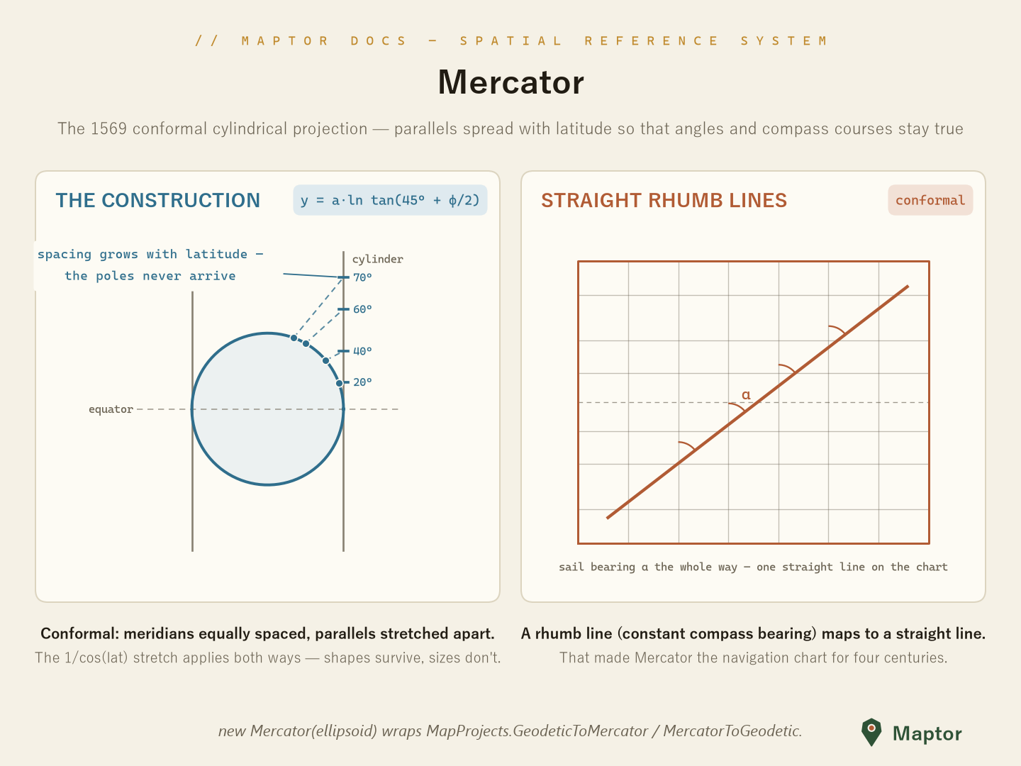
The conformal cylindrical projection (Gerardus Mercator, 1569). Meridians stay equally spaced while parallels spread apart as y = a·ln tan(45° + φ/2), exactly matching the E–W stretch — so angles survive everywhere. Its killer feature: a rhumb line (a course of constant compass bearing) maps to a straight line, which made it the navigation chart for four centuries. The price: scale inflates by 1/cos(φ) and the poles sit at infinity.
var mercator = new Mercator(Ellipsoids.WGS84);

var xy  = mercator.FromGeodetic(new Point(51.389, 35.689));
var geo = mercator.ToGeodetic(xy);
UTM — Universal Transverse Mercator
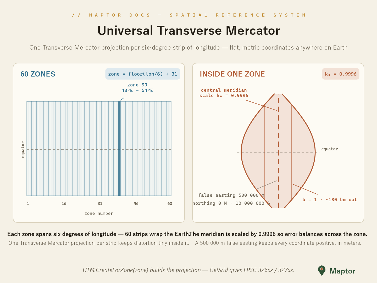
UTM slices the world into 60 zones of longitude, six degrees each (zone = floor(lon / 6) + 31). Each zone gets its own Transverse Mercator projection centered on the zone's central meridian, scaled by k₀ = 0.9996 so scale error balances across the zone, with a false easting of 500 000 m so every easting stays positive. The result: flat, metric coordinates with tiny distortion anywhere inside the zone.
using IRI.Maptor.Core.Common.Primitives;
using IRI.Maptor.Core.SpatialReferenceSystem;
using IRI.Maptor.Core.SpatialReferenceSystem.MapProjections;

// Zone 39 covers 48°E–54°E (e.g. Tehran); WGS84 by default
var utm = UTM.CreateForZone(39);

var projected = utm.FromGeodetic(new Point(51.389, 35.689));   // lon, lat -> easting, northing
var geodetic  = utm.ToGeodetic(projected);                     // and back

int srid = UTM.GetSrid(39, isNorthHemisphere: true);           // 32639 (EPSG)
Related helpers in MapProjects: FindUtmZone(longitude), CalculateCentralMeridian(zone), GeodeticToUTM(...) / UTMToGeodetic(...), and CalculateUTMScaleFactor(...) for the point scale factor away from the central meridian.
Web Mercator (EPSG:3857)
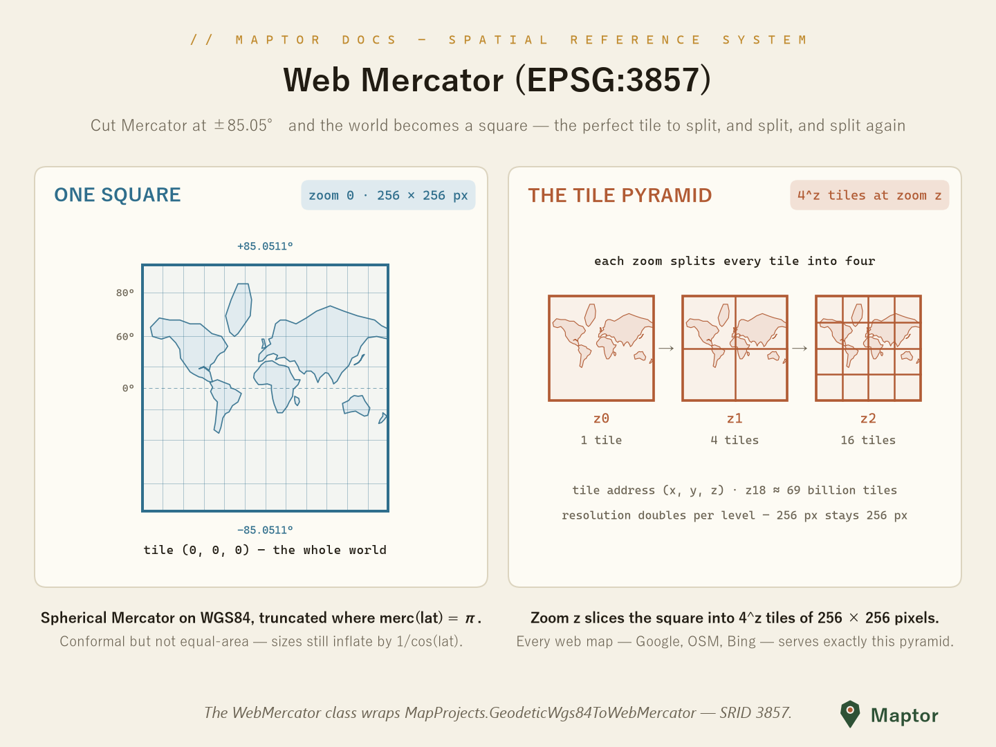
Web Mercator is the projection behind virtually all web tile maps (Google, OSM, Bing, …). It applies the spherical Mercator formulas to WGS84 geodetic coordinates ("auxiliary sphere") and truncates the map at ±85.0511° — precisely the latitude where the Mercator y equals π·a — so the whole world becomes a square.
That square is the point: at zoom 0 the world is one 256 × 256 px tile; every zoom level splits each tile into four, giving 4ᶻ tiles at zoom z (1 → 4 → 16 → …, about 69 billion at z18) addressed by (x, y, z). Resolution doubles per level while each tile stays 256 px — the pyramid every slippy map serves.
It is conformal but not equal-area: scale still grows by 1/cos(latitude), so never measure areas or distances directly in Web Mercator coordinates.
var webMercator = new WebMercator();

var xy  = webMercator.FromGeodetic(new Point(51.389, 35.689)); // lon, lat -> meters (EPSG:3857)
var geo = webMercator.ToGeodetic(xy);

// or call the math directly:
var xy2 = MapProjects.GeodeticWgs84ToWebMercator(new Point(51.389, 35.689));
Lambert Conformal Conic
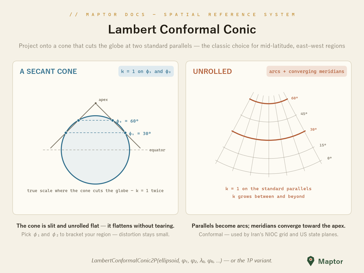
Project onto a cone that cuts the globe at one or two standard parallels, then slit the cone and unroll it: parallels become concentric arcs, meridians straight lines converging on the apex. Scale is true (k = 1) on the standard parallels and grows away from them, so choosing φ₁ and φ₂ to bracket your region keeps distortion small — the classic conformal choice for mid-latitude, east–west extents (US state plane zones, and Iran's NIOC grid on the Clarke 1880 RGS datum).
// two standard parallels bracketing the region of interest
var lcc = new LambertConformalConic2P(
    Ellipsoids.WGS84,
    standardParallel1: 30,
    standardParallel2: 36,
    centralMeridian: 53,
    latitudeOfOrigin: 33);

var xy  = lcc.FromGeodetic(new Point(51.389, 35.689));
var geo = lcc.ToGeodetic(xy);
LambertConformalConic1P is the single-parallel variant: the cone is tangent at latitudeOfOrigin (its cone constant is n = sin(latitudeOfOrigin)).
Cylindrical Equal-Area
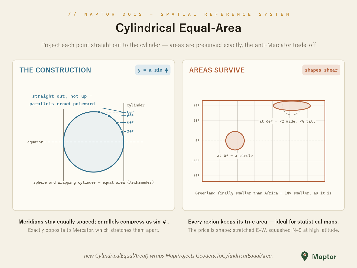
Project each point horizontally out to the wrapping cylinder: y = a·sin φ. By Archimedes' hat-box theorem a sphere and its wrapping cylinder have equal area, so this preserves areas exactly — the anti-Mercator. Parallels compress toward the poles instead of spreading; shapes pay the price, stretching E–W and squashing N–S at high latitudes (a Tissot circle at 60° becomes twice as wide and half as tall — same area). Use it when areas must be honest: density, land-cover, and statistical maps.
var cea = new CylindricalEqualArea();               // WGS84 by default

var xy  = cea.FromGeodetic(new Point(51.389, 35.689));
var geo = cea.ToGeodetic(xy);
Back to IRI.Maptor.Core.SpatialReferenceSystem · datums and ellipsoids are documented in Models.